Tuesday, November 16, 2021

MUGHAL BRIDGE LANDMARK PESHAWAR PAKHTUNKHWA 1600 AD


The Mughal Bridge is 100 yards long and six yards wide with beautiful, domed pillars

The Mughal tands above Bara River and near the Chuha Gujar village. Chuha Gujar Villege is situated where the southern Part of Ring road is exiting to GT road and motorway as Junction .

Just before this Junction is another Intersection or chowk when Pandu Road road crosses the southern Ring road of Peshawar, when you take a Right turn on Pandu road , you will have Chuha Gujar villege on your left .


A Mughal-era construction probably built during Shah Jehan’s rule in 1629, the bridge is 100 yards long and six yards wide with six-foot tall pillars on each side. The pillars are topped with beautiful domes which add to the grandeur of the bridge. Two of the domes, however, have fallen off. As is typical of Mughal architecture, there are 12 arched tunnels or water ways running under the bridge.


The Chuha Gujar Bridge is 100 yards long and six yards wide with beautiful, domed pillars. PHOTOS: MUHAMMAD IQBAL/EXPRESS


The bridge is in considerably good condition, despite the fact that it has been there for more than three centuries and has not been preserved as a historical site. It is among the few Mughal monuments in the city of Peshawar. In his book, Peshawar: Past and Present, SM Jafar shows the original plaque with Emperor Shah Jehan’s name and details of the bridge on it, such as the date of construction.


One of the pillars used to have a plaque with details about the historic bridge, but it has been removed. Researcher Humayun Akhund said residents claimed the plaque was taken away by officials from the archeology department. He added that they had searched the department and found nothing. “If we had the plaque, we would be able to learn about the bridge’s history,” he said. “But since we do not have any historical documents or manuscripts, we don’t know much. The structure and design show that this was built in the Mughal period.”


According to researcher Muhammad Nawaz Khan, who has written about the history of Peshawar, many people believe the bridge was built by Karim Bakhsh Sethi, a philanthropist from Peshawar. There is, however, no proof. Khan added there was another bridge on the road between Chamkani village and GT Road which was constructed by Sethi. He claimed there used to be a mosque near the bridge but it doesn’t exist anymore.


Wednesday, July 7, 2021

PESHAWAR GRAVEYARD OF DURRANI AFGHAN ROYALS FAMOUS FOR 2ND ANGLO AFGHAN WAR 1878.


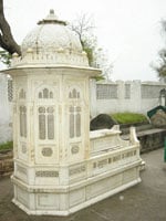
Grave of Prince Ayub Khan in Peshawar 


The tablet at the cemetery gate reads: "The mausoleum of  Maiwand's Victor Ghazi Sardar Mohammed Ayub Khan" (b.1855 d.1914). Afghan Prince Ayub Khan's tomb made of pure white marble is a fine example of hand craftsmanship. It has a round canopy and bears beautiful floral carvings, geometric patterns and Islamic calligraphy.


The mausoleum's construction was commissioned by the government of Afghanistan during the reign of King Amir Habibullah Khan. The gravestone carries a Persian inscription that lavishes much praise on the inmate. 


Other dignitaries buried in the Durrani Graveyard compound include: 

1. Mother of Prince Ayub Khan and wife of King Ameer Sher Ali and queen of Afghanistan), 
2. Sardar Ibrahim Khan (brother),
3. Sardar Jalaluddin Khan 
4. and other close family members of the monarchy. 


Door Way Plaque 


The graveyard also has rare historic headstones dating back to the late 1700s and early 1800s when Peshawar was ruled by the Durrani Pashtuns Dynasty of Afghanistan and their Rule extended from Afghanistan to Delhi.


Queen of Afghanistan at Wazir Bagh Peshawar  mother of  Prince Ayub Khan 


Location:

In the compound of Shiekh Habib Baba Ziarat (near 'Beejo ka Makbara') near Wazir Bagh Road outside walled city of Peshawar) Located on the southern side outside the walled city of Peshawar on Wazir Bagh Road Near the Famous Wazir Bagh .

There  is a historic muslim cemetery dating back to 1700 and 1800 at , the time when Peshawar was the winter capital of Afghanistan and Delhi under the Durrani Empire of Pashtuns Ahmadzai Branch of Yousafzai.

In Peshawar Near Wazir Bagh lies the tomb of Afghan prince Sardar Ayub Khan of Maiwand fame. He was the son of Sher Ali, Amir (King) of Afghanistan, and cousin of Amir Abdur Rahman.


Introduction of The Victor of Maiwand Prince Sardar Muhammad Ayub Khan:  


Durrani Empire was Started by Ahmad Shah Abdai Durrani who was Titled Durrani ( King of Kings  ) as He was Destined to be King of Afghanistan , India ( Pakistan Included )  , at same time .  After Ahmad Shah His some Timur Shah Took over and then Zaman Shah and Kamran Shah and Later ,Dost Muhammad Durrani and followed by Amir Sher Ali Durrani .

This Dynasty lasted in India till 1857 and in Afghanistan till Sardar Daud Durrani in 1980,s  who was Killed by Taliban / Mujahideen .

Amir Sher Ali son was Prince Ayub Khan Durrani and he was also Governor of Herat and Kandahar Province. 


Prince Ayub Khan 1855-1914


He was an Afghan National hero and Prince of India Sub continent and Afghanistan and He was the son of the King Ameer Shere Ali, who ruled Afghanistan from 1863-1878. Ayub Khan was born in 1855 and spent most of his early life in Afghanistan. of Afghanistan and rests in a small marble mausoleum in this Durrani Graveyard, Peshawar. 

After Ayub Khan father's King of Afghanistan Amir Sher Ali Khans demise and Ayub Khan became the governor of Herat and His brother King Amir Yakub Khan ascended the throne as King of Indian Sub Continent and Afghanistan , as Durand Line was not Made Till 1898 and Afghanistan Possessed all Area of Pakistan and Indian till Delhi India .


King Amir Sher Ali King of Indian sub Continent till Delhi 


Sardar Muhammad Ayub Khan is revered as a freedom fighter and national hero in Afghanistan. 

19th century poets have composed ballads about the 'Ghazi of Maiwand' and glorified him for giving the foreign invaders a bloody nose. There is a monument of the battle of Maiwand in Afghanistan. 

The tower, known as Minar-e-Maiwand was erected by King Zahir Shah Durrani in 1959 in the town square.


Malalaa Of Maiwand 


A Pashto inscription, taken from a poem, relates a legend how at one stage the Afghans were Preparing for retreat when a young woman named Malalai, stepped forward and pleaded to them: "If you do not taste of martyrdom today on this field of Maiwand, by God I am afraid you'll lead an ignominious life forever." It is recounted, upon hearing this the men turned back to win the battle.

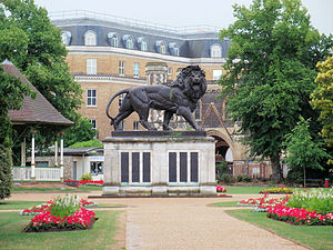
A colossal cast-iron lion statue in the memory of the men of 66th Regiment of Foot who died at Maiwand stands in Forbury Gardens, Reading in Berkshire England UK. 


The Maiwand Lion, Forbury Gardens, Reading 2.jpg
Maiwand Lion at Forbury Gardens commemorating the fallen Soldiers 


The Maiwand Lion is a sculpture and war memorial in the Forbury Gardens, a public park in the town of Reading, in the English county of Berkshire. The statue was named after the Battle of Maiwand and was erected in 1886 to commemorate the deaths of 329 men from the 66th (Berkshire) Regiment of Foot during the campaign in Afghanistan between 1878 and 1880. It is sometimes known locally as the Forbury Lion.


The Maiwand Lion features on the front page of one of the local newspapers, the Reading Post, and also on the Reading Football Club crest.

The regiment lost approximately 329 to 500 (reports of the number vary) at the battle of Maiwand, having faced an Afghan army by the British contingent. Eleven of the men were Officers, protecting the colours. 

 Sir Arthur Conan Doyle based his character Doctor Watson on the regiment's Medical officer, Surgeon Major Doctor A F Preston who was injured in battle.

Sir Arthur Conan Doyle's fictional character Watson is actually based on a surgeon of the 66th Regiment. In 'A Study in Scarlet' (1881), Watson describes how he got shot whilst attending to a fallen soldier at Maiwand. "How are you? You have been to Afghanistan, I perceive" are the opening words spoken by Sherlock Holmes to Dr. Watson. "How on earth did you know that?", Watson asks in admiration. It is the first of many displays of Holmes's brilliant deductive abilities.


Plaque of  Maiwand Lion  at Forbury Park . 

The few remaining survivors that managed to reach the safety of the British garrison at Kandahar, got a medal from Queen Victoria of England on return to their country. One of the medal recipients was a dog named Bobbie.

King Ameer Sher Ali and Sons including Ayub Khan  

The unprecedented British defeat caused a sensation in Europe and provided much literary food for English writers such as Rudyard Kipling who composed a poem entitled 'That Day'. Rudyard Kipling also Invented the Term " The Great Game " which meant the The chasing the Wealth of Center of Earth Afghanistan according to Mc Kinder Theory and found at Silk Route and all the rulers of Indian Sub continent came from Afghanistan for last thousands of Years.

After Prince Ayub Khan's victory under the direction of Field Marshall Frederick Roberts was Sent By East India company to Punish Afghan  after a few months it also left Afghanistan after burning Many Bazaars in Kandahar and Kabul and Punishing Afghans with Brutality that showed lack of humanity and reminded People of Third Rate Barbarism . 

And when the British army drew back into India leaving the Afghans to govern themselves, Ayub's cousin and staunch enemy King Amir Abdur Rahman Khan proclaimed himself Ameer routing Ayub's supporters. 

Ayub Khan was forced to flee to Herat and later sought refuge in Persia where he spent many years in exile. The new King Ameer Abdur Rahman continued to hatch conspiracies against him and made his life difficult even there.

On his part, Ayub Khan tried vainly to topple him and attempted a coup against his cousin but with no luck. As time wore on and the political landscape gradually changed Ayub Khan finally turned himself over to the British emissary in Mashad, Persia. 

He was sent to India as a state prisoner and kept in confinement for sometime. He spent the last years of his life with his family in Lahore, living off a pension fixed by the Government of India. He died on April 7, 1914 and was buried in Peshawar.

Today, the Victor of Maiwand rests alone in his glory in a small marble mausoleum in the Durrani Graveyard near Wazir Bagh, Peshawar , just outside the old walled city of Peshawar.

 His tomb made of pure white marble is a fine example of hand craftsmanship. It has a round canopy and bears beautiful floral carvings, geometric patterns and Islamic calligraphy. The mausoleum's in Peshawar construction was commissioned by the government of Afghanistan during the reign of King Habibullah Khan in 1914. 

The Great Game and Anglo Afghan Wars 

The term 'Great Game' was popularized during the British Empire's conflict with Tsarist Russian Empire in the 19th century. Afghanistan and its monarchs became pawns in this imperial game of rivalry and strategic influence and its outcome was to have a direct bearing on the British Empire's hold over India.

Great Game was Rivalry Between British and Russia over the Riches and Resources of Afghanistan and  Central Asia beyond Afghanistan till Bukhara and Samarkand .

Many Wars were fought to Conquer Afghanistan and expand British Sphere of Influence they are

1. First Anglo Afghan War 1839-1842.
2. Second Anglo Afghan War 1878-1880.
3. Third Anglo Afghan War  1913-1914.

The British had not forgotten the terrible first Afghan War disaster when an entire army of 15,000 was wiped out in 1842 during Retreat from Kabul ending the four years of their initial presence there in Snow and harsh Weather and Pashtun tribes shooting them from Mountains above .

Retribution and vengeance were key considerations that paved the way for another military campaign. Incited by the murder of the British agent Major Louis Cavagnari at the Kabul Residency and to counter the increasing tilt towards Russia by the Afghans, the British army once again advanced into Afghanistan in 1878 commencing the second Afghan War at Maiwand . 

Maiwand is a small village town in Afghanistan, about 45 miles from Kandahar that gained fame during the second Anglo-Afghan War in 1880. It was at this battlefield that the British army suffered its most embarrassing defeat at the hands of Prince Sardar Muhammad Ayub Khan, whose mausoleum is in Peshawar.

Soon after their arrival, the British deposed Ayub's brother Yakub Khan and then a long campaign ensued. The battle at Maiwand was fought on July 27, 1880 when Ayub Khan successfully led 6000 men and intercepted the British army at this place in order to thwart their invasion of Afghanistan. 

The terrible heat of the Afghan summer that year and other logistic difficulties greatly disadvantaged the 66th (Berkshire) Regiment led by General Burrows in its advance and was annihilated by the Afghans who tore through all its lines. The victory is often cited as being perhaps the only instance where an Asiatic leader won a pitched battle fought against a vastly superior European army.

1880 Victory day at Maiwand under Prince Ayub Khan

Prince Ayub Khan confronted the British force commanded by General Burrows at Maiwand, on 27th July 1880, near the close of the Both Second Afghan and First Afghan war are Example of wins one of the very few pitched battles that have been won by any Asiatic leaders over an army under European direction.


Wednesday, June 2, 2021

THE ROOF TOP OF WORLD & 8000 METER PLUS MOUNTAINS & 150 7000 METERS PLUS MOUNTAINS LIST.


Viewfrom Space of Hindu Kush Mountains 


Roof Top of the World is Situated in Khyber Pakhtunkhwa and Northern Areas of Pakistan and it Posses Hundreds of Mountains that are Highest in the World that it Shares with China , Afghanistan , Nepal and India 


Northern areas of Pakistan Known as Gilgit & Baltistan are Right next to Khyber Pakhtunkhwa and you have to Pass from this Area to Reach the Northern Areas and the Roof top of the World where Hundreds of Mountains are Situated that are more then 7000 Meters High and also there are 5 Mountains that are Included in the 8000 meters plus 14 Mountains of the World  


Karakorum Range of Mountains :


Karakoram is a Turkic term meaning black gravel. The name was first applied by local traders to the Karakoram Pass.

Karakorum is also a Sub Range of Hindu Kush Mountain that is found in Pakistan in the Khyber Pakhtunkhwa and Northern Area of Gilgit and Baltistan. The Karakoram is in one of the world's most geologically active areas, at the boundary between two colliding continents of Europe and Asia and Found on Boundary of Pakistan Durand line with Afghanistan and in North from these Mountain Ranges this Boundary starts and finished near Arabia Sea.


K2 in Karakorum

A significant part, 28-50% of the Karakoram Range is glaciated, compared to the Himalaya (8-12%) and Alps (2.2%).Mountain glaciers may serve as an indicator of climate change, advancing and receding with long-term changes in temperature and precipitation.[9] Karakoram glaciers are mostly stagnating or enlarging, because, unlike in the Himalayas, many Karakoram glaciers are covered in a layer of rubble which insulates the ice from the warmth of the sun. Where there is no such insulation, the rate of retreat is high.

The Karakoram, in simplified Chinese: 喀喇昆仑山脉; traditional Chinese: 喀喇崑崙山脈; pinyin: Kālǎkūnlún Shānmài; , Kārākōram; Balti: ཁརན ཨ ཀུརམ Kharan-a-Kuram Uyghur: كاراكورم‎), is a large mountain range spanning the borders between Pakistan, India and China, located in the regions of Gilgit–Baltistan (Pakistan), Ladakh (India), and Xinjiang region (China).

As subrange of the Hindu Kush Himalayan Range, it is one of the Greater Ranges of Asia. The Karakoram is home to the highest concentration of peaks over 8000m in height to be found anywhere on earth, including K2, the second highest peak in the world 8,611 m (28,251 ft).


Nanga Parbat

The range is about 500 km (311 mi) in length, and is the most heavily glaciated part of the world outside the polar regions. The Siachen Glacier at 76 kilometres (47 mi) and the Biafo Glacier at 63 kilometres (39 mi) rank as the world's second and third longest glaciers outside the polar regions.

The Karakoram is bounded on the northeast by the edge of the Tibetan Plateau, and on the north by the Pamir Mountains. The southern boundary of the Karakoram is formed, west to east, by the Gilgit, Indus, and Shyok Rivers, which separate the range from the northwestern end of the Himalaya range proper as these rivers converge southwestward towards the plains of Pakistan.


Broad Peak

The Tashkurghan National Nature Reserve and the Pamir Wetlands National Nature Reserve in the Karalorun and Pamir mountains have been nominated for inclusion in UNESCO in 2010 by the National Commission of the People's Republic of China for UNESCO and has tentatively been added to the list.

The naming and division of the various subranges of the Karakoram is not universally agreed upon. However, the following is a list of the most important subranges, following Jerzy Wala. The ranges are listed roughly west to east.


Sub Ranges are :

1. Batura Muztagh,

2. Rakaposhi-Haramosh Mountains,

3. Spantik-Sosbun Mountains

4. Hispar Muztagh

5. South Ghujerab Mountains

6. Panmah Muztagh

7. Wesm Mountains

8. Masherbrum Mountains

9. Baltoro Muztagh

10. Saltoro Mountains

11. Siachen Muztagh

12. Rimo Muztagh

13. Saser Muztagh

Passes in Karakorum are :

From west to east

1. Karakoram Pass

2. Kilik Pass

3. Mintaka Pass

4. Khunjerab Pass (the highest paved international border crossing at 4,693 m (15,397 ft))

5. Shimshal Pass

6. Mustagh Pass

7. Sasser Pass

Karakorum High way Passes through these Mountains and is Marvelous feet of Engineering and one of Highest Highway in the world , and it was Made by Chinese and Pakistani Army Engineers and it is a marvel to See.


The List of Mountains in Karakorum Range are As follows:

Nanga Parbat 8,125 Meters high is found in Diamer Region , About 37 Mountains are Found in Gaunche Region , 64 Mountain in Gilgit Region and 50 Mountain in Skardu region all Higher then 7KM or 7000 Meters are found in Northern Areas of Pakistan. All in All 152 Mountains are found in Karkorum Sub range of Hindu Kush Mountains .


                                         Gasher Brum 2


In This List the 31 Mountains of Pamir Sub Ranger of Hindu Kush Mountains Khyber Pakhtunkhwa about are not included found in Chitral Region also Known as Roof Top of the World .

1  Nanga Parbat
Height  Range         Group        District
8,125 Himalayas    Diamer        Diamer


2  Saltoro Kangri No. I
Height  Range         Group        District
7,742  Karakoram   Soltoro    Gaunche

3 Saltoro Kangri II 
Height  Range         Group        District
7,706  Karakoram   Soltoro    Gaunche

4 Chhaltoro Gang R1 N
Height  Range         Group        District
7,705  Karakoram  Soltoro  Gaunche

5 Saser Kangri I
Height  Range         Group        District
7,672   Karakoram   Siachen (disputed)  Gaunche

6  Mamostong Kangri
Height  Range         Group        District
7,516  Karakoram Soltoro       Gaunche

7  Saser Kangri E
Height  Range         Group                   District
7,513   Karakoram  Siachen (disputed) Gaunche

8 Saser Kangri II W
Height  Range         Group                    District
7,500   Karakoram Siachen (disputed) Gaunche

9 Saser kangri III
Height  Range         Group        District
7,495 Karakoram Siachen (disputed) Gaunche

10 K-12  
Height  Range         Group        District
7,469  Karakoram Soltoro        Gaunche

11 Teram Kangri 1
Height  Range         Group                   District
7,463 Karakoram  Siachen (disputed) Gaunche

12 Teram Kangri II
Height  Range         Group                       District
7,406   Karakoram  Siachen (disputed)  Gaunche

13 Rimo (S) No. I Peak 51
Height  Range         Group                    District
7,385   Karakoram  Siachen (disputed) Gaunche

14 Teram Kangri III
Height  Range         Group        District
7,382  Karakoram Siachen (disputed)  Gaunche

15 Sherpi Kangri I Main
Height  Range         Group        District
7,380 Karakoram Soltoro Gaunche

16 Rimo (S) No. II P-50
Height  Range         Group                    District
7,373  Karakoram Siachen (disputed) Gaunche

17 Sherpi Kangri No. II
Height  Range         Group        District
7,370 Karakoram  Soltoro Gaunche

18 Sherpi Kangri No. III
Height  Range         Group                   District
7,300 Karakoram  Siachen (disputed) Gaunche

19 Teram kangri IV
Height  Range         Group        District
7,300  Karakoram   Siachen (disputed)Gaunche

20 K-6
Height  Range         Group        District
7,282 Karakoram Saltoro       Gaunche

21 Apsarasas-1
Height  Range         Group        District
7,245 Karakoram Siachen (disputed) Gaunche

22 Apsarasas II
Height  Range         Group                   District
7,239 Karakoram Siachen (disputed)  Gaunche

23 Apsarasas III E
Height  Range         Group                    District
7,236 Karakoram Siachen (disputed)  Gaunche

24 Rimo No. II P-49
Height  Range         Group        District
7,233 Karakoram Siachen (disputed) Gaunche

25 Apsarasas IV
Height  Range         Group               District
7,227 Karakoram Siachen (disputed) Gaunche

26 Mt. Rose/Singhi Kan
Height  Range         Group                 District
7,202 Karakoram Siachen (disputed) Gaunche

27 Apsarasas V
Height  Range         Group                District
7,187 Karakoram Siachen (disputed)Gaunche

28 Apsarasas III E
Height  Range         Group                    District
7,184 Karakoram  Siachen (disputed)Gaunche

29 Apsarasas III W
Height  Range         Group                  District
7,181 Karakoram Siachen (disputed) Gaunche

30 Rimo No. III
Height  Range         Group                   District
7,169 Karakoram Siachen (disputed) Gaunche

31 Un-Named/Masherbrum
Height  Range         Group        District
7,163  Karakoram Siachen (disputed)  Gaunche

32  Depak
Height  Range         Group        District
7,150 Karakoram  Siachen (disputed) Gaunche

33 Apsarasas (S)
Height  Range         Group                  District
7,117 Karakoram Siachen (disputed) Gaunche

34 Sherpi Kangri
Height  Range         Group                    District
7,100 Karakoram   Siachen (disputed) Gaunche

35 Link Sar
Height  Range         Group        District
7,041 Karakoram  Siachen (disputed) Gaunche

36 Apsarasas(E)/Un-Named
Height  Range         Group        District
7,000 Karakoram  Siachen (disputed) Gaunche

37 Chogolisa(W)/Prupoo
Height  Range         Group        District
7,000 Karakoram Boltoro Gaunche

38 Ghent III
Height  Range         Group                     District
7,000 Karakoram Siachen (disputed)  Gaunche

39 Kaberi Peak
Height  Range         Group               District
7,000 Karakoram Siachen (disputed)Gaunche

Gilgit Mountains


1 Distaghil Sar Main
Height  Range         Group        District
7,885 Karakoram  Hispar          Gilgit

2 Kunyang Chhish/Main
Height  Range         Group        District
7,852 Karakoram  Hispar          Gilgit

3  Masherbrum NE/ (K-1)
Height  Range         Group        District
7,821 Karakoram   Bagrot        Gilgit

4  Masherbrum
Height  Range         Group        District
7,806 Karakoram   Bagrot     Gilgit

5  Rakaposhi
Height  Range         Group        District
7,788 Karakoram  Bagrot          Gilgit

6  Batura No. I
Height  Range         Group              District
7,785  Karakoram  Batura Mustagh  Gilgit

7  Batura II
Height  Range         Group             District
7,762 Karakoram   Batura Mustagh  Gilgit

8  Distaghil Sar No. II
Height  Range         Group        District
7,760   Karakoram  Hispar         Gilgit

9 Kanjut Sar No. I
Height  Range         Group        District
7,760  Karakoram   Hispar     Gilgit

10   Batura No. II
Height  Range         Group        District
7,730 Karakoram Batura Mustagh Gilgit

11 Batura III
Height  Range         Group                       District
7,729 Karakoram   Batura Mustagh  Gilgit Mustagh

17  Batura IV 
Height  Range         Group        District
7,594 Karakoram Mustagh       Gilgit

18 Batura V 
Height  Range         Group        District
7,531 Karakoram    Batura Mustagh Gilgit

19 Yakshin Gardaan No. I
Height  Range         Group        District
7,530 Karakoram  Hispar          Gilgit

20 Kunyang Chhish (W)
Height  Range         Group        District
7,500 Karakoram   Hispar        Gilgit

21  Pumari Chhish (W)
Height  Range         Group        District
7,492  Karakoram  Hispar    Gilgit

22 Pasu Massive M
Height  Range         Group        District
7,478 Karakoram  Batura Mustagh  Gilgit

23 Malubiting (W)_
Height  Range         Group        District
7,453 Karakoram  Haramosh Gilgit

24 Muchu Chhish
Height  Range         Group            District
7,453 Karakoram  Batura Muztagh Gilgit

25 Pumari Chhish (N)
Height  Range         Group        District
7,440  Karakoram Hispar  Gilgit

26 Yazghil Dome (S)
Height  Range         Group        District
7,440 Karakoram Hispar          Gilgit

27 Haramosh No. I
Height  Range         Group        District
7,409 Karakoram Haramosh  Gilgit

28 Kunyang Chhish (E) 
Height  Range         Group        District
7,400 Karakoram Hispar   Gilgit

29 Pumari Chhish (S)
Height  Range         Group        District
7,400 Karakoram Hispar   Gilgit

30 Yazghil Dome (N)
Height  Range         Group        District
7,400  Karakoram  Hispar       Gilgit

31 Ultar Sar No. I
Height  Range         Group        District
7,388 Karakoram Batura Mustagh Gilgit

32 Karun Kuh
Height  Range         Group        District
7,350 Karakoram  Hispar          Gilgit

33 Kunyang Chhish W
Height  Range         Group        District
7,350 Karakoram Hispar   Gilgit

34 Pumari Chhish S 
Height  Range         Group        District
7,350 Karakoram  Hispar   Gilgit

35 Momhil Sar / Peak - 7
Height  Range         Group        District
7,343 Karakoram   Hispar  Gilgit

36 Yutmaru Sar (S)
Height  Range         Group        District
7,330 Karakoram    Hispar       Gilgit

37 Bojohagur Duanasir
Height  Range         Group             District
7,329 Karakoram  Batura Mustagh Gilgit

38 Kunyang Chhish (SE)
Height  Range         Group        District
7,320 Karakoram  Hispar        Gilgit

39  Malanghutti
Height  Range         Group        District
7,320 Karakoram  Hispar         Gilgit

40  Ultar Sar II
Height  Range         Group        District
7,310 Karakoram    Batura Mustagh  Gilgit

41 Yazghil Domes N
Height  Range         Group        District
7,300  Karakoram Hispar           Gilgit

42   Malubiting Central
Height  Range         Group        District
7,291  Karakoram Haramosh      Gilgit

43 Rakapohsi (E)
Height  Range         Group        District
7,290 Karakoram Bagrot            Gilgit

44 Passu/Peak No. 55
Height  Range         Group            District
7,284 Karakoram Batura Mustagh Gilgit

45 Pasu Massiv E
Height  Range         Group              District
7,284 Karakoram Batura Muztagh Gilgit

46 Diran /Minapin
Height  Range         Group        District
7,273 Karakoram Bagrot           Gilgit

47 Bularang Sar
Height  Range         Group        District
7,200 Karakoram Hispar           Gilgit

48 Lugpahur Sar MD
Height  Range         Group        District
7,200 Karakoram Hispar           Gilgit

49  Lupghar Sar (E)
Height  Range         Group        District
7,200 Karakoram Hispar           Gilgit

50 Malubiting LC
Height  Range         Group        District
7,200 Karakoram Haramosh     Gilgit

51 Kampir Dior
Height  Range         Group        District
7,168 Karakoram Batura Muztagh Gilgit

52 Karun Koh
Height  Range         Group        District
7,164 Karakoram Khunjerab     Gilgit

53 Hachindar Chish
Height  Range         Group        District
7,163 Karakoram Batura Mustagh  Gilgit

54 Kampir Dior
Height  Range         Group        District
7,143 Karakoram Batura Mustagh  Gilgit

55 Kunyang Chhish (N)
Height  Range         Group        District
7,108 Karakoram Hispar          Gilgit

56 Ghenta
Height  Range         Group        District
7,100 Karakoram Batura Mustagh Gilgit

57 Lupghar II / Central
Height  Range         Group        District
7,100 Karakoram Hispar           Gilgit

58  Yakshin Gardaan No. I
Height  Range         Group        District
7,100 Karakoram Hispar  Gilgit

59 Ghenta
Height  Range         Group        District
7,090 Karakoram Batura Muztagh Gilgit

60 Malubiting (E)
Height  Range         Group        District
7,010 Karakoram  Haramosh Gilgit

61Rakaposhi (E)
Height  Range         Group        District
7,010 Karakoram  Bagrot          Gilgit

62 Lupghar Sar III (E)
Height  Range         Group        District
7,000 Karakoram Hispar           Gilgit

63 Sangemer Mar
Height  Range         Group        District
7,000 Karakoram Batura Muztagh  Gilgit

64 Malubiting (NW)
Height  Range         Group        District
7,300 Karakoram  Haramosh Gilgitt


Skardu District Mountains


1 Chogori/K-2
Height  Range         Group        District
8,611 Karakoram Boltoro        Skardu

2  Gasherbrum No. I/Hidden Peak
Height  Range         Group        District
8,068  Karakoram  Boltoro     Skardu

3 Falchan Kangri / Broad Peak
Height  Range         Group        District
8,047  Karakoram Boltoro      Skardu

4 Gasherbrum No. II
Height  Range         Group        District
8,035  Karakoram   Boltoro      Skardu

5  Broad Peak Middle/Central
Height  Range         Group        District
8,016 Karakoram    Boltoro      Skardu


6  Gasherbrum No. III
Height  Range         Group        District
7,952 Karakoram  Boltoro        Skardu

7  Gasherbrum No.lV
Height  Range         Group        District
7,925 Karakoram    Boltoro      Skardu

8 Masherbrum W
Height  Range         Group        District
7,750  Karakoram   Boltoro      Skardu

9 Chogolisa No. I SW/E
Height  Range         Group        District
7,665 Karakoram   Boltoro        Skardu


10 Chogolisa No. II/NE
Height  Range         Group        District
7,654 Karakoram    Boltoro      Skardu

11 Broad Peak (N)
Height  Range         Group        District
7,550 Karakoram    Boltoro      Skardu

12 Skyang Kangri No.I
Height  Range         Group        District
7,544 Karakoram    Boltoro      Skardu

13 Skyang Kangri No. II
Height  Range         Group        District
7,500 Karakoram Boltoro        Skardu

14 Sia Kangri No I / N
Height  Range         Group        District
7,422 Karakoram    Boltoro      Skardu

15 Skil Brum
Height  Range         Group        District
7,360 Karakoram   Boltoro       Skardu


16  Skyang Kangri M
Height  Range         Group        District
7,357 Karakoram    Boltoro       Skardu

17  Skyang Kangri W
Height  Range         Group        District
7,345 Karakoram   Boltoro       Skardu


18 Sia Kangri No II/E
Height  Range         Group        District
7,325 Karakoram   Boltoro        Skardu

19 Yazghil Domes S
Height  Range         Group        District
7,324    Karakoram  Boltoro    Skardu


20 Gasherbrum No. V
Height  Range         Group        District
7,321 Karakoram    Boltoro      Skardu

21 Baltoro Kangri No. I
Height  Range         Group        District
7,312   Karakoram  Boltoro       Skardu


22 Baltoro Kangri No. III
Height  Range         Group        District
7,300   Karakoram   Boltoro     Skardu

23 Urdok No. I
Height  Range         Group        District
7,300 Karakoram Boltoro         Skardu

24 Savoia Kangri
Height  Range         Group        District
7,286  Karakoram   Boltoro       Skardu

25 Baintha Brakk/Ogre
Height  Range         Group        District
7,285 Karakoram    Panmah    Skardu

27 Baltoro Kangri No. III
Height  Range         Group        District
7,280 Karakoram   Boltoro      Skardu

28 Golden Throne SE
Height  Range         Group        District
7,275  Karakoram   Boltoro       Skardu

29 Golden Throne NW
Height  Range         Group        District
7,274  Karakoram   Boltoro      Skardu

30 Mustagh Tower (E)
Height  Range         Group        District
7,273 Karakoram   Boltoro      Skardu

31 Sia Kangri No. IV/Central
Height  Range         Group        District
7,273 Karakoram    Boltoro       Skardu


32 Golden Throne NE
Height  Range         Group        District
7,270    Karakoram  Boltoro    Skardu

33 Mustagh Tower (W)
Height  Range         Group        District
7,270 Karakoram    Boltoro     Skardu

34 Golden Throne SE
Height  Range         Group        District
7,265   Karakoram  Boltoro      Skardu

35 Summari
Height  Range         Group        District
7,263   Karakoram  Boltoro     Skardu

36 Baltoro Kangri No. V
Height  Range         Group        District
7,260 Karakoram    Boltoro      Skardu

37 Baltoro Kangri No. IV
Height  Range         Group        District
7,254  Karakoram   Boltoro      Skardu

38 Urdok Kangri I
Height  Range         Group        District
7,200 Karakoram Boltoro         Skardu


39 Mustagh Tower (NW)
Height  Range         Group        District
7,180 Karakoram Boltoro         Skardu

40 Yermanenbu Kangri
Height  Range         Group        District
7,163 Karakoram    Boltoro     Skardu

41 Un-Named
Height  Range         Group        District
7,150 Karakoram   Boltoro       Skardu

42  Latok No. I
Height  Range         Group        District
7,145   Karakoram Panmah      Skardu

43 Gasherbrum V
Height  Range         Group        District
7,133 Karakoram   Boltoro      Skardu

44 Urdok No. II
Height  Range         Group        District
7,082 Karakoram   Boltoro      Skardu


45 Mandu Pk
Height  Range         Group        District
7,081 Karakoram    Boltoro   Skardu

46  Chogolisa Kangri I
Height  Range         Group        District
7,071 Karakoram Boltoro         Skardu

47 Pyramid/Thyor
Height  Range         Group        District
7,058   Karakoram Boltoro    Skardu

48 Spantik/Ghenish Chish
Height  Range         Group        District
7,027 Karakoram  Haramosh    Skardu

49 Chogolisa Kangri II
Height  Range         Group        District
7,014   Karakoram  Boltoro     Skardu


50 Gasherbrum No. VI
Height  Range         Group        District
7,004  Karakoram Boltoro        Skardu


Thursday, May 20, 2021

7000 METERS PLUS 31 MOUNTAINS OF KHYBER PAKHTUNKHWA


As Islam Spread from Afghanistan to India after Afghanis crossed these Mountains to Bring Islam to India they are called as a Result Hindu Kush or Eliminator of Hindus in Hindi language although it also contains Solomon Range and his Takht ( Kings Seat ) Attributed to Hazrat Solomon PBUH the Prophet of Jews of King Solomon and Queen Sheba fame.


The Hindu Kush , also known as Pāriyātra Parvata , Caucasus Indicus, or Paropamisadae , is an 800 km (500 mi) long mountain range that stretches between central Afghanistan and northern Pakistan. It is a subrange of the Himalayan range.


Hindu Kush Mountains 


The Hindu Kush system stretches about 966 kilometres (600 mi) laterally West to East , but its median north-south measurement is about 240 kilometres (150 mi).


Ranges of Hindu Kush 


Only about 600 kilometers (370 mi) out of the 966 kilometers (600 mi) Total Hindu Kush system is called the Proper Hindu Kush mountains. The rest of the 366 KM of Hindu Kush System consists of numerous smaller mountain ranges including :

  1. Karkorum Range ( Pakistan).
  2. Soloman Range ( Pakistan).
  3. Pamir Range( Pamir Range)
  4. Koh-e Baba Range 
  5. Salang.Range 
  6. Koh-e Paghman.Range 
  7. Siah Koh Range  (also called the eastern Tor Ghar )
  8. Koh-e Khwaja Mohammad Range 
  9. Selseleh-e Band-e Turkestan.Range 
  10. Safēd Kōh – eastern / The Spin Ghar Range 
  11. Safid Koh -western  Range / Paropamise by western scholars, though that name has been slowly falling out of use over the last few decades its Parts are (Malmand, Chalap Dalan, Siah Band and Doshakh)


The mountains of the Hindu Kush system diminish in height as they stretch westward towards Kabul Toward the middle, near Kabul, they extend from 4,500 to 6,000 meters (14,800 to 19,700 ft); in the west, they attain heights of 3,500 to 4,000 meters (11,500 to 13,100 ft).The average altitude of the Hindu Kush is 4,500 meters (14,800 feet).


Rivers that flow from the mountain system include:


Helmand River,
Hari River
Kabul River( Peshawar)
Watershed from the Sistan Basin.

Numerous high passes ("kotal") transect the mountains, forming a strategically important network for the transit of caravans.


Hindu Kush mountain passes are:


1. Khyber Pass ( Landi Kotal) Pakistan (1,027 m).


2. Salang Pass (Kotal-e Salang) Afghanistan (3,878 m); it links Kabul and points south of it to northern Afghanistan. The completion of a tunnel within this pass in 1964 reduced travel time between Kabul and the north to a few hours. The Salang tunnel at 3,363 m and the extensive network of galleries on the approach roads were constructed with Soviet financial and technological assistance and involved drilling 1.7 miles through the heart of the Hindu Kush.

3. Tang-e Gharu Pass Afghanistan , superseded in 1960 by a road constructed within the Kabul River's most spectacular gorge, the This remarkable engineering feat reduced travel time between Kabul and the Pakistan border from two days to a few hours.


4- Kotal-e Shibar Afghanistan Previously access to the north through this Kotal/Pass (3,260 m) took three days.


5- Kotal-e Lataband Afghanistan (2,499 m) east of Kabul.

6- Shotorgardan (3,720 m), linking Logar and Paktiya provinces.

7- Bazarak (2,713 m), leading into Mazari Sharif.


8- Khawak Pass (4,370 m) in the Panjsher Valley.

9- Anjuman Pass (3,858 m) Panjsher Valley giving entrance to the north.

10- The Hajigak (2,713 m)

11- Unai (3,350 m) lead into the eastern Hazarajat and Bamyan Valley.


7000 Meter Plus Mountains of Khyber Pakhtunkhwa:


In Khyber Pakhtunkhwa 31 Mountains exists above 7,000 Meters or 7KM vertically , 

Important for Mountaineering and are situated vertically from Sea level with Lowest one about 7,020 Meters and the Highest one called Trichmir Main vertically About 7,708 Meters in Highest Situated in World top 10 Highest Mountains of world and also Visible from Commercial Aircraft as Far as Islamabad and while Landing .


Trich Mir in Chitral

it is a sub range of the Hindu Kush Himalayan range. It divides the valley of the Amu Darya (the ancient Oxus) in Afghanistan to the north from the Indus River valley to the south. The highest point in the Hindu Kush is Tirich Mir (7,708 m or 25,289 ft) in Chitral District of Khyber Pakhtunkhwa, Pakistan.

To the east the Hindu Kush buttresses the Pamir range Situated inside of Pakistan near the point where the borders of China, Pakistan and Afghanistan meet, after which it runs southwest through Pakistan and into Afghanistan, finally merging into minor ranges in western Afghanistan. The mountain range separates Central Asia from South Asia .

Giglit Baltistan and Chitral Part of Khyber Pakhtunkhwa Forms this Pamir Range although some of it is In Afghanistan and Tajikistan.


The Eastern Hindu Kush range, also known as Pamirs is also Known as “ Roof Top of the World “ , mostly located in northern Pakistan and the Nuristan and Badakhshan provinces of Afghanistan . 

In Pakistan’s Chitral District of Khyber Paktunkhwa is home to Tirich Mir, Noshaq, and Istoro Nal, the highest peaks in the Hindu Kush. The range also extends into Ghizar, Yasin Valley, and Ishkoman in Pakistan's Northern Areas.


The highest point in the Hindu Kush is Tirich Mir (7,708 m or 25,289 ft) in Chitral District of Khyber Pakhtunkhwa, Pakistan.

To the east the Hindu Kush buttresses the Pamir range near the point where the borders of China, Pakistan and Afghanistan meet, after which it runs southwest through Pakistan and into Afghanistan, finally merging into minor ranges in western Afghanistan. The mountain range separates Central Asia from South Asia.


Trich Mir in Pamir


Chitral is considered to be the pinnacle of the Hindu Kush region. The highest peaks, as well as countless passes and massive glaciers, are located in this region. The Chiantar, Kurambar, and Terich glaciers are amongst the most extensive in the Hindu Kush and the melt water from these glaciers form the Kunar River, which eventually flows south into Afghanistan and joins the Bashgal, Panjsher, and eventually the much smaller Kabul River.


Mountain Passes which join Afghanistan to Chitral, Pakistan, include the Baroghil (3,798 m) and the Kachin (5,639 m), which also cross from the Wakhan corridor a small Few KM Area with 4 time zones of 4 countries ie Pakistan , Afghanistan , China and Tajikistan .


There are a number of other important passes in Afghanistan China and Pakistan in Pamirs , it The Wakhjir Pass (4,923 m), proceeds from the Wakhan Corridor into Xinjiang, China, and into Northern Areas of Pakistan.


Passes which join Afghanistan to Chitral, Pakistan, include the Baroghil (3,798 m) and the Kachin (5,639 m), which also cross from the Wakhan.


Pamir Valley or the Chitral Valleys is Most beautiful and also best place to Visit in Khyber Pakhtunkhwa and is journey of Life Time to See the breathtaking beauty and Nature at its best among the Pamir Ranger of mountains of Hindu Kush in Khyber Pakhtunkhwa.


The Kilash Tribe and Chitralis and Gilgit,s Live here who are here who celebrate their Festivals and also are Pagan Tribe who have their own customs and are slowly Losing their culture and being Assimilating in Islamic culture .


Pamirs forms the Starting Point of Durand Line in North , that Divides the Afghanistan Tajikistan and Pakistan and it is also called the “ Roof Top of the world “, 


Lord Curzon the Head of East india Company Personally came and visited this Places and he was one who Invented Durand line , border between Afghanistan and India later Adopted as Pakistan Border with Afghanistan .


Pamir valley Is situated here in Gilgit and Chitral Pakhtunkhwa and starts from Wahkhan corridor that belongs to 4 countries Afghanistan , Pakistan , Tajikistan and China.

The Wakhan Corridor (alternatively Vakhan Corridor, or Wakhan) is the narrow strip of territory in northeastern Afghanistan that extends to China and separates Tajikistan from Pakistan. The corridor, wedged between the Pamirs to the north and the Hindu Kush to the south, is about 350 km (220 mi) long and 13–65 kilometres (8.1–40.4 mi) wide.


Inside the Wakhan Corridor is a high mountain valley from which the Panj and Pamir Rivers emerge and form the Amu Darya. 

A trade route through the valley has been used by travelers going to and from East, South and Central Asia since antiquity. Wakhan Corridor can also refer to the valley and the trade route. 

The closure of the Afghan-Chinese border crossing at the Wakhjir Pass at the east end of the Wakhan Corridor, however, has turned the valley into a cul de sac inhabited by nomads.

The corridor was a political creation of the Great Game. On the corridor's north side, agreements between Britain and Imperial Russia in 1873 and between Britain and Afghanistan in 1893 effectively split the historic region of Wakhan by making the Panj and Pamir Rivers the border between Afghanistan and the Russian Empire. On its south side, the Durand Line agreement of 1893 marked the boundary between British India and Afghanistan. 

This left a narrow strip of land as a buffer between the two empires, which became known as the Wakhan Corridor in the 20th century. As of 2010, the Wakhan Corridor had 12,000 inhabitants.

 The northern part of the Wakhan is also referred to as the Afghan Pamir which is in Afghanistan .
The Wakhan Corridor forms the panhandle of Afghanistan's Badakhshan Province. At its western entrance near the Afghan town of Ishkashim, the corridor is 18 km (11 mi) wide.[1] The western third of the corridor varies from 13–30 km (8.1–18.6 mi) in width and widens to 65 km (40 mi) in the central Wakhan. At its eastern end, the corridor forks into two prongs that wrap around a salient of Chinese territory, forming the two countries' 92 km (57 mi) boundary. 

The Wakhjir Pass, on the southeastern prong is about 300 km (190 mi) from Ishkashim.

The easternmost point of the northeastern prong is about 350 km (220 mi) from Ishkashim. On the Chinese side of the border is Tashkurgan Tajik Autonomous County of Xinjiang Uyghur Autonomous Region.

The northern border is formed by the Pamir River and Lake Zorkul in the west and the high peaks of the Pamir Mountains in the east. To the north is Tajikistan's Gorno-Badakhshan Autonomous region.

In the south, the corridor is bounded by the high mountains of the Hindu Kush and Karakoram. The Broghol and Irshad Passes along the southern flank offer access, respectively, to Khyber Pakhtunkhwa and Gilgit Baltistan on Pakistan's side of the border. The Dilisang Pass is disused.

The corridor is higher in the east (the Wakjir Pass is 4,923 m (16,152 ft) in elevation) and descends to about 3,037 m (9,964 ft) at Ishkashim.

The Wakhjir River emerges from an ice cave on the Afghan side of the Wakhjir Pass and flows west, joining the Bozai Darya near the village of Bozai Gumbaz and forms the Wakhan River. The Wakhan River then joins the Pamir River near Kala-i-Panj to form the Panj River, which then flows out of the Wakhan Corridor at Ishkashim.

Chinese descriptions of the Wakhan Corridor include the Taghdumbash Pamir, a high mountain valley east of the Wakhjir Pass that is about 100 km (62 mi) long.[7][8] This valley, through which the Tashkurgan River flows, is generally about 3–5 km (1.9–3.1 mi) wide and less than 1 km (0.62 mi) at its narrowest point.


The List of 31 Mountains Khyber Pakhtunkhwa Mountains are as following:


1  Tirich Mir (Main)     

Height  Range         Group        District
7,708   Hindukush  Hindukush  Chitral


2    Tirich Mir (East)
Height  Range         Group        District 
7,692   Hindukush  Hindukush  Chitral

3 Tirich Mir (West II)
Height  Range         Group        District 
7,500   Hindukush   Hindukush  Chitral

4  Tirich Mir (West I) 
Height  Range         Group        District 
7,487  Hindukush   Hindukush  Chitral

5 Istro-Nal (Main)
Height  Range         Group        District 
7,403 Hindukush  Hindukush   Chitral 

6 Tirich Mir (West III)
Height  Range         Group        District 
7,400 Hindukush Hindukush Chitral

7  Istro-Nal (North I)
Height  Range         Group        District
7,373 Hindukush Hindukush Chitral

8 Istro-Nal (North II)
Height  Range         Group        District
7,372 Hindukush Hindukush Chitral

9   Istro-Nal (North III)
Height  Range         Group        District
7,365 Hindukush Hindukush Chitral

10  Saragharar (Main)
Height  Range         Group        District
7,349  Hindukush Hindukush Chitral

11   Saraghrar (Central)
Height  Range         Group        District
7,330 Hindukush Hindukush Chitral

12   Saragharar (S)
Height  Range         Group        District
7,307  Hindukush  Hindukush  Chitral

13  Istro-Nal (South)
Height  Range         Group        District
7,303  Hindukush Hindukush Chitral

14 Istro-Nal (West I)
Height  Range         Group        District
7,300 Hindukush Hindukush    Chitral

15  Saraghrar (NW)
Height  Range         Group        District
7,300  Hindukush Hindukush Chitral

16 Istro-Nal (West II)
Height  Range         Group        District
7,280 Hindukush Hindukush Chitral

17  Istro-Nal (Northwest)
Height  Range         Group        District
7,276 Hindukush Hindukush Chitral

18 Saraghrar (SW-I)
Height  Range         Group        District
7,250  Hindukush Hindukush Chitral

19 Saraghrar (SE-I)
Height  Range         Group        District
7,208 Hindukush Hindukush Chitral

20 Istro-Nal (X)
Height  Range         Group        District
7,200 Hindukush Hindukush Chitral

21 Saraghrar (SW-II)
Height  Range         Group        District
7,200  Hindukush   Hindukush  Chitral

22  Shakawar  
Height  Range         Group        District
7,125 Hindukush Hindukush Chitral

23  Koh-I-Nadir Shah
Height  Range         Group        District
7,116  Hindukush Hindukush Chitral

24  Udren Zom (N)
Height  Range         Group        District
7,108 Hindukush Hindukush Chitral

25  Langar (Main)
Height  Range         Group        District
7,100 Hindukush Hindukush Chitral

26   Saraghrar (SS)
Height  Range         Group        District
7,100  Hindukush Hindukush Chitral

27 Udren Zom (Central)
Height  Range         Group        District
7,080  Hindukush Hindukush  Chitral

28  Langar (SE)
Height  Range         Group        District
7,061 Hindukush  Hindukush Chitral

29  Udren Zom (S)
Height  Range         Group        District
7,050  Hindukush Hindukush  Chitral

30  Saraghrar (N)  
Height  Range         Group        District
7,040   indukush Hindukush Chitral

31 Akber Chioh/Akher
Height  Range         Group        District
7,020  Hindukush  Hindukush Chitral.


Sunday, October 11, 2020

ADVENTURE IN KHYBER PAKHTUNKHWA


Adventure Foundation is an Organization functioning since 1980 , that Provides Adventure Facilities and trainings for

1.            Mountaineering
2.            Rock  Climbing
3.            Snow Skiing
4.            Trekking ,
5.            Gliding 
6.            River Boating
7.            and Hot Air Ballooning .

This Area where these Adventures Take Places is in Pakhtunkhwa Province Area who’s capital is Peshawar.

Training is Done in Mangal Area Near Abbottabad area and this is only 2-3 Hours Drive from Peshawar Capital of Pakhtunkhwa and After training mostly Adventure Events are Held in Pakhtunkhwa like in AbbottAbad, Like Hot Air Ballooning, Hang Glider Activities , River Boating and Also Mountain Climbing techniques.

Some of Activities also takes Places near Khanpur Dam about Few KM Before Abbotabad and comes in Way of Peshawar and Abbotabad.  , Other Activities takes places in Swat and  Malakand Area of Pakhtunkhwa and Much More in Chital city of Khyber Pakhtunkhwa.


IN FANA Northern Areas  Like Hunza and Gilgit Mountaineering and Rock Climbing Takes Palace as well although it is very far off from Abbottabad and Peshawar and Situated in Northern Area of Pakistan called FANA (Federally Administered Northern Tribal Areas). some Actvities have Taken Place in Kashmir as well. 

The Organization is Run by Retired Army Professionals and is very Great in Adventure and Outdoor Activities that is world Famous .

Please Ask and Email and Telephone and Schedule as Activities are Planned from Ahead . I enjoyed the Gliding and Hot Air Ballooning and it was Wonderful Experience and it really made me fall in Love with Beauty of Khyber Pakhtunkhwa when seen from above , an Amazing Experience of Life time .

CONTACT DETAILS FOR ADVENTURE FOUNDATION 

PESHAWAR
Dr. Hamid Ahmad

92-A, Defence Colony, Khyber
Road, Peshawar. Ph: 0333-913534

ABBOTTABAD
Brig Jan Naidr Khan (R)
Director General
Mob: 0300-9199571
Khalid Khalil
Director

Mob: 0300-9116727
Adventure Foundation Pakistan
Outdoor Pursuit Training Centre
Mangal Abbottabad
Phone: (0992) 370215
Fax: (0992) 371103
E-mail:
katcpk@yahoo.com
afpatc@adventurefoundation.org.pk

ISLAMABAD
Brig. Muhammad Akram Khan
President.

Mob: 0333-5240709
Syed Jawad Mehboob
Member Administration
Secretariat
Jehan Ara Mueem
General Secretary

Mob: 0333-5207000
Ikram Bashir
Deputy Director

Operational Unit
Mob: 0300-9708434
Brig. M.M. Karim (R)
Chief Instructor,

Hot Air Ballooning School
Director Aerial Division
Adventure Complex
Garden Avenue, National Park Area
P.O. Box 1807, Islamabad-44000
Ph: (051) 2825805, 2512158
Fax: (051) 2607494
Email: afpisb@adventurefoundation.org.pk
www.adventurefoundation.org.pk